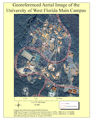
Having done some digitizing in the past I was a little familiar with the concept presented here but thought it was interesting to see how the images, especially the south section, moved after each point was referenced. The keys to being successful I thought were patience and the willingness to go back and re-evaluate all your previous points based on their Root Mean Square (RMS) value and image correctness after continuing to add points. Often I found that I could delete an old point whose RMS had gone up to ~7 or 8 and redo the point to an RMS of ~4 or 5 lowering the overall RMS total. I also found that it was important to try to place points on the road, provided it was relatively easy to select a location such as an intersection or crosswalk where you could be relatively close in your reference. Doing so seemed to be the best way to get the road image to line up with the road vector.

Hey Sean,
ReplyDeleteLong time no talk. Nice map. I've been swimming in it the past couple of weeks at work...hoping to participate more from here on out though. Take care, Brian